
How hard is it to hike to the bottom of the Grand Canyon and back in one day?

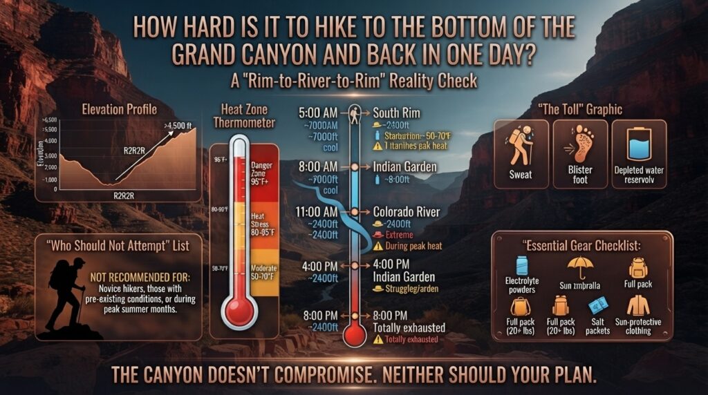
Hiking to the floor of the Grand Canyon and returning to the rim in a single day is widely considered one of the most grueling, deceptive, and physically demanding day hikes in North America.
While the prospect of standing on the banks of the Colorado River before dusk attracts thousands of ambitious travelers—from San Francisco tech professionals to adventure-seekers from New York, Texas, Washington, and across California—the reality of this 16-to-19-mile round-trip trek surprises even seasoned ultra-marathoners.
At myecoadventure.com, our mission is to empower outdoor enthusiasts with honest, actionable, and eco-conscious travel intelligence. In this ultimate guide, we evaluate the exact physical difficulty, key route profiles, safety risks, seasonal timing, regional travel planning, and provide a 10-question FAQ to help you decide if a Grand Canyon single-day floor-and-back hike is right for you.
The Short Answer: Is It Doable, and Should You Do It?
In terms of sheer technical difficulty, hiking to the bottom of the Grand Canyon and back in one day is extremely hard (Rated 10/10).
Unlike traditional mountain peaks where you climb uphill first while your legs are fresh and descend when tired, the Grand Canyon inverts the classic mountain profile:
- The Downward Trap: You spend your first 3 to 4 hours walking continuously downhill, gravity assisting every step. This leads many hikers into a false sense of security.
- The Inverted Ascent: To return, you must climb roughly 4,300 to 4,800 vertical feet over 7 to 9 miles on tired legs, moving into progressively thinner air and higher ambient temperatures as you ascend.
- The Microclimate Heat Engine: Temperatures at the canyon floor near Phantom Ranch regularly exceed 110°F to 120°F (43°C to 49°C) in the summer—often 20°F to 25°F hotter than at the rim.
The National Park Service (NPS) strongly discourages attempting to hike from the rim to the river and back in a single day. Dozens of heat-illness evacuations and multiple heat-related fatalities occur annually along these corridors, primarily involving fit hikers who underestimated the heat, elevation loss, and hydration demands.
Key Metrics: Trail Stats at a Glance
To understand the scope of a single-day inner-canyon trip, compare the two primary corridors used by day hikers (the South Kaibab Trail and the Bright Angel Trail):
The steep elevation loss profile of the South Kaibab Trail down to Phantom Ranch.. Source: Medium
| Metric | South Kaibab to Phantom Ranch & Up Bright Angel | South Kaibab (Down & Up) | Bright Angel (Down & Up) |
|---|---|---|---|
| Total Round-Trip Distance | ~16.5 miles (26.5 km) | ~14.2 miles (22.8 km) | ~19.0 miles (30.5 km) |
| Total Elevation Loss / Gain | 4,780 ft down / 4,380 ft up | 4,780 ft loss & gain | 4,380 ft loss & gain |
| Average Completion Time | 9 to 12 Hours | 8 to 11 Hours | 10 to 14 Hours |
| Water Available on Trail | Seasonal at Havasupai Gardens & Resthouses | NO water on South Kaibab trail | Water available at key resthouses (seasonal) |
| Shade Profile | Very low descending; moderate ascending | Extremely low (completely exposed) | Partial morning shade in upper canyon |
| Difficulty Rating | Extreme / Strenuous | Extreme / Exposed | Extreme / Endurance |
Crucial Trail Recommendation: If you attempt a single-day trek to the river, the universally recommended route is the “South Kaibab Down, Bright Angel Up” loop. South Kaibab offers a shorter, steeper descent with superior morning views, while Bright Angel provides drinking water stations, seasonal resthouses, and shaded sections for your grueling return climb.
Why Is the Hike So Deceptively Hard? The 5 Hidden Hazards
1. The Inverted Elevation Curve
On a mountain summit hike, if you get tired 3 miles in, you simply turn around and coast downhill back to your car. In the Grand Canyon, turning around when tired means you still have the hardest, steepest uphill portion of your journey ahead of you.
[ Traditional Mountain Climb ]              [ Grand Canyon Inverted Hike ]
       Summit (Hardest)                            Rim Trailhead (Start)
          /\                                              \         /
         /  \                                              \       /  Uphill Climb
 Easy   /    \  Easy                                Downhill\     /   (Fatigued)
 Start /      \ Finish                                Easy   \   /
      /        \                                              \ /
 Rim /          \ Rim                                     River Floor
                                                        (Heat & Exhaustion)
2. Extreme Thermal Radiation & Microclimates
The South Rim sits at 7,000 feet (2,134 m) above sea level, where air is cool and pine trees flourish. As you descend 1 vertical mile to the Colorado River at 2,400 feet (730 m), you pass through five distinct ecological zones.
The basalt and granite inner gorge acts as a thermal convection oven. Radiating heat off black rock walls can push ground-level air temperatures past 120°F (49°C) between June and August.
The floor of the Grand Canyon near Phantom Ranch along the Colorado River.. Source: USGS.gov
3. Hyponatremia vs. Dehydration
Most hikers know they need to drink water, but drinking too much plain water without replacing electrolytes leads to hyponatremia—a life-threatening condition where blood sodium levels plummet. Symptoms include confusion, nausea, brain swelling, and loss of motor control.
- You must balance fluid intake with salty snacks, electrolyte tablets, or endurance fuels.
4. Eccentric Muscle Fatigue
Walking downhill for 4 continuous hours places heavy, eccentric contraction stress on your quadriceps and knees. By the time you reach Phantom Ranch, your leg muscles have suffered micro-tears, making the subsequent 4,400-foot upward climb significantly more painful than a normal uphill ascent.
5. High Altitude at the Rim Finish
Because the return finish line rests between 6,800 and 7,000 feet, your lungs must work harder to draw oxygen during the final 3 miles—the exact point where physical exhaustion is at its absolute peak.
Regional Logistics: Advice for Out-of-State Visitors
At myecoadventure.com, we regularly advise travelers flying in from major metropolitan hubs. Where you travel from impacts your elevation acclimation and sleep schedule:
From San Francisco & Bay Area, CA
- Flight Strategy: Fly non-stop from SFO/OAK/SJC into Las Vegas (LAS) or Phoenix (PHX), then drive 3.5 to 4 hours to the South Rim.
- Key Challenge: Bay Area residents live at sea level. Arriving at the 7,000-foot South Rim and hiking down the next morning without 24–48 hours of altitude adjustment increases susceptibility to acute mountain sickness (AMS).
From Seattle & Washington State
- Flight Strategy: Direct flights from SEA to PHX offer quick access.
- Key Challenge: Moving from cool, humid Pacific Northwest climates directly into desert heat triggers rapid sweat loss. PNW hikers should schedule their trips in late fall or spring (October, April, May) to avoid heat shock.
From Texas (Austin, Dallas, Houston)
- Road & Air Routes: Direct flights from DFW or IAH to Phoenix take ~2.5 hours; driving via I-40 takes 12–16 hours.
- Key Challenge: Texas heat is humid, whereas Grand Canyon heat is dry and windy. In dry air, sweat evaporates almost instantly, masking how rapidly you are losing water.
From New York & Tri-State Area
- Flight Strategy: Non-stop transcontinental flights (JFK/EWR to PHX) take ~5.5 hours.
- Key Challenge: Jet lag combined with a 3:30 AM alpine start for the hike can compromise reaction speed and cardiovascular endurance. Plan a full rest day at the rim prior to hiking.
Ideal Seasons: When Is a Single-Day River Hike Safest?
Attempting this hike during the wrong month can convert a tough workout into a medical emergency. Here is how the seasons stack up:
[ JAN - FEB ]   ──► Winter Conditions  ──► Ice/Snow on Rim; Microspikes Required
[ MAR - MAY ]   ──► Prime Season       ──► Comfortable Temps; Book Early
[ JUN - AUG ]   ──► DANGER ZONE        ──► Floor Temps >115°F; DO NOT ATTEMPT DAY HIKE
[ SEP - NOV ]   ──► Prime Season       ──► Crisp Air; Ideal Canyon Floor Weather
1. Mid-Spring (April – May): BEST
- Conditions: Rim temperatures range from 50°F to 70°F; canyon floor reaches 80°F to 90°F.
- Pros: Water stations are turned on along Bright Angel Trail; daylight hours are long.
2. Autumn (Late September – November): BEST
- Conditions: Stable weather, lower humidity, and mild canyon floor temperatures (75°F–85°F).
- Pros: Reduced risk of monsoon flash floods; ideal for sustained physical pacing.
3. Winter (December – February): MODERATE TO ADVANCED
- Conditions: South Rim icy and covered in snow; river floor pleasant (55°F–65°F).
- Pros: Zero heat stress at the canyon floor.
- Cons: Extremely short daylight hours (~10 hours); top 2 miles of trails require microspikes or crampons for packed ice.
4. Summer (June – August): EXTREMELY DANGEROUS
- Conditions: Rim heat reaches 85°F–95°F; inner canyon exceeds 115°F–120°F.
- Verdict: Do not attempt a day hike to the river in summer. The NPS rescues dozens of heat-stroke victims annually during these months.
What to Pack: The Day Hiker’s Survival Gear List
If you are qualified, trained, and weather-cleared to attempt this journey, proper gear selection is mandatory.
                                [ DAY PACK ESSENTIALS ]
                                           │
      ┌───────────────────┬────────────────┼───────────────────┬───────────────────┐
      ▼                   ▼                ▼                   ▼                   ▼
 [ Hydration System ]  [ Electrolytes ] [ Trail Nutrition ]  [ Sun Protection ]  [ Emergency Tech ]
 - 3-4L Capacity       - Salt Packets   - 3,000+ Calories    - Wide-Brim Hat     - Satellite Messenger
 - Hydration Bladder   - Nuun / Liquid  - Salty Pretzels     - Sunscreen / UV    - Headlamp + Extra
   + Bottle Backup       IV Mix           Bars / Jerky         Long Sleeve         Batteries
- Hydration System: Minimum 3 to 4 liters capacity (combination of a back-pack bladder and a rigid water bottle for mixing powder).
- Electrolytes & Salty Food: Salt tablets, chews, pretzels, peanut butter packets, and jerky. Plan for 200–300 calories per hour.
- Sun Protection: UPF 50+ sun shirt, wide-brim hat, polarized sunglasses, and zinc-based sunscreen.
- Footwear & Socks: Broken-in trail running shoes or lightweight hiking boots paired with merino wool anti-blister socks.
- Illumination: Headlamp (minimum 300 lumens) with spare batteries—you will start and likely finish in total darkness.
- First Aid & Traction: Blister kit (Leukotape/Moleskin), anti-inflammatory medication, microspikes (if hiking Dec–March), and a satellite messenger (Garmin inReach).
Eco-Friendly & Leave No Trace Rules for Inner Canyon Hikers
At myecoadventure.com, preserving wilderness environments is at the heart of our philosophy:
- Pack Out ALL Trash (Including Food Waste): Dried fruit pits, banana peels, and apple cores do not decompose quickly in arid environments and attract wildlife to trail corridors.
- Use Designated Restroom Facilities: Pit toilets are located at Cedar Ridge, Tipoff, Bright Angel Campground, Havasupai Gardens, and 1.5/3-Mile Resthouses. If forced to go between stations, pack out your toilet paper in a sealed plastic bag.
- Yield to Mule Trains: Mules have the right-of-way. When encountering a mule string, step off the trail to the uphill side, stand completely still, and follow the wrangler’s instructions.
- Never Touch or Feed Wildlife: Grand Canyon rock squirrels are notorious biters and carry diseases. Keep your pack sealed at rest stops.
10 Frequently Asked Questions (FAQ)
FAQ 1: How long does it take to hike to the bottom of the Grand Canyon and back?
For a highly conditioned hiker, the round trip takes 8 to 12 hours. Average completion times typically break down as 3 to 4 hours descending South Kaibab Trail, 1 hour resting at Phantom Ranch/Bright Angel Creek, and 5 to 7 hours ascending Bright Angel Trail.
FAQ 2: Has anyone died attempting this day hike?
Yes. Multiple hikers die every year in the Grand Canyon, with heat illness (hyperthermia), dehydration, hyponatremia, and cardiac arrest being the leading causes among day hikers. The National Park Service places warning signs featuring “Exhausted Pete” at major trailheads to warn visitors of these risks.
FAQ 3: Can I sleep at Phantom Ranch or Bright Angel Campground without a permit?
No. Overnight stays at Phantom Ranch require winning a competitive lottery up to 15 months in advance. Camping at Bright Angel Campground or Havasupai Gardens requires an advance backcountry permit issued by the NPS. You cannot spontaneously stay overnight if you get tired on a day hike.
FAQ 4: Is there cell phone service inside the canyon?
Cell service is extremely spotty to non-existent inside the canyon. You may get weak signals near the South Rim edge, but once you descend past the rim, expect zero cellular coverage. Carrying a satellite communicator (e.g., Garmin inReach or ACR Bivy Stick) is strongly recommended for emergencies.
FAQ 5: What is the single best advice for the return climb?
Pace yourself and rest in shade. Take 5-minute shade breaks every 30 to 45 minutes, soak your shirt and hat in cold water at creek crossings or water spigots to utilize evaporative cooling, and maintain a slow, rhythmic “rest step” uphill.
FAQ 6: Should I take South Kaibab down or Bright Angel down?
Always take South Kaibab DOWN and Bright Angel UP. South Kaibab is shorter (6.8 miles to the river) and steeper with no shade or water, making it far safer to descend in the cool morning hours. Bright Angel is 9.5 miles long with seasonal water stations and shade, making it much safer for the grueling uphill climb.
FAQ 7: How early should I start the hike in the morning?
Start before dawn—ideally between 3:30 AM and 5:00 AM. Getting on the trail early allows you to complete the descent and reach the inner gorge before peak heat sets in around 11:00 AM.
FAQ 8: Are trekking poles really necessary?
Yes! Trekking poles reduce force loads on your knees and quadriceps by up to 20–25% on the downhill descent and provide critical balance and upper-body assistance during the steep 4,400-foot upward climb.
FAQ 9: Is it better to wear heavy hiking boots or trail running shoes?
Lightweight, breathable trail running shoes with good traction are preferred by most modern Grand Canyon day hikers. Heavy leather boots hold in heat and increase foot fatigue over a 17+ mile trek.
FAQ 10: What if I realize I cannot finish the climb back up?
There are no rescue elevators, rides, or regular mule pickups for fatigued day hikers. Unless you suffer a life-threatening medical emergency requiring an air-evacuation helicopter, you must walk out on your own power. If you feel overwhelmed, stop in a shaded area (like Havasupai Gardens), hydrate, eat salty foods, rest for 1–2 hours, and continue slowly during cooler evening hours.
Conclusion
Hiking to the bottom of the Grand Canyon and back in one day is an incredible physical test, but it is not a casual bucket-list activity. It demands rigorous cardiovascular conditioning, careful route strategy, disciplined electrolyte management, and total respect for mountain elevation and desert heat.
If you choose to undertake this adventure, plan your trip for spring or autumn, start before sunrise, take the South Kaibab Down / Bright Angel Up route, and pack light, eco-conscious essentials.