How difficult is it to hike to the ground of the Grand Canyon and back in a single day?

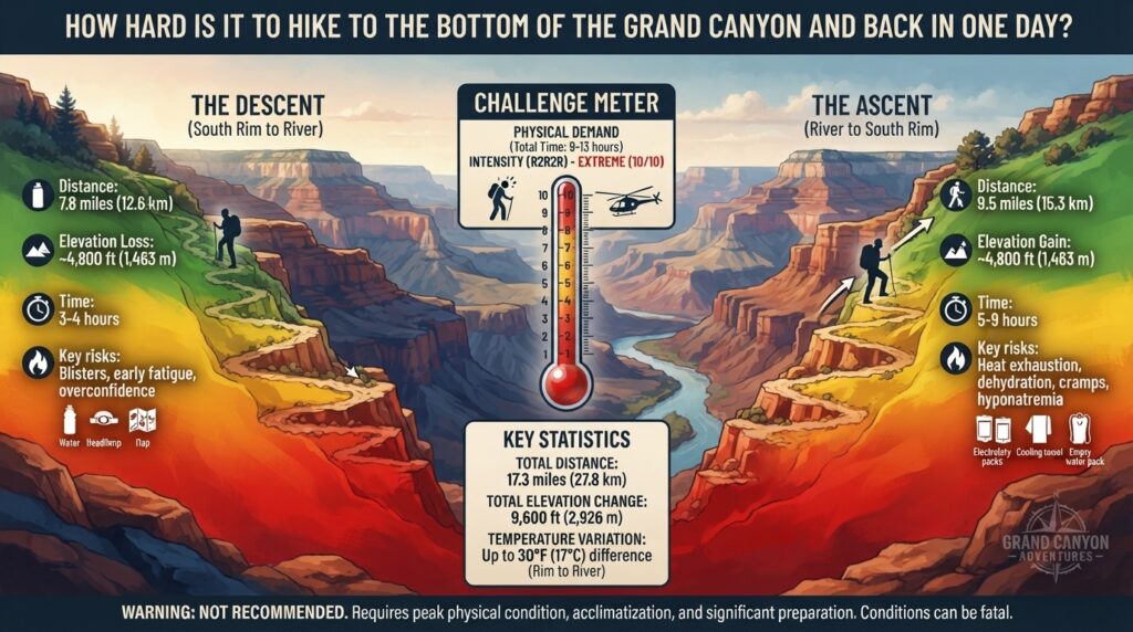
For outdoor enthusiasts across Texas, New York, California, Washington, and San Francisco planning their next bucket-list thrill, few endurance challenges carry the legendary status of hiking to the bottom of the Grand Canyon and returning in a single day. Known in the trekking community as a Rim-to-River-to-Rim (R2R2R) day hike, this intense trek descends over 4,000 vertical feet to the Colorado River and requires a unrelenting climb back up through vast desert terrain.
Is it doable? Yes, for well-prepared endurance athletes and experienced desert hikers.
Is it extremely difficult—and potentially dangerous? Absolutely. The National Park Service (NPS) explicitly warns against attempting to hike from the rim to the river and back in one day, particularly during warm-weather months, due to severe heat illness, extreme elevation changes, and physical exhaustion.
This comprehensive guide breaks down the physical demands, route profiles, crucial gear reviews, survival tips, and top 10 FAQs for tackling the Grand Canyon in a day safely.
1. The Physiological Reality: Why The Grand Canyon Kills Unprepared Hikers
Unlike standard mountain hikes where the hardest work occurs at the beginning during the ascent, the Grand Canyon inverted topography flips standard physical dynamics on its head.
The Inverted Elevation Profile
When you start at the South Rim (7,000 feet) or North Rim (8,000 feet), your day begins with effortless downward gravity. Descent feels easy, misleading hikers into pushing far deeper and faster than their cardiovascular conditioning supports.
The return journey demands climbing 4,300 to 5,800 vertical feet over 7 to 14 miles after your legs have already absorbed thousands of eccentric muscle contractions going downhill.
Extreme Microclimates & Furnace Heat
The temperature at the South Rim does not reflect the climate at the canyon floor. On average, the bottom of the canyon near Phantom Ranch (elev. 2,480 ft) is 20°F to 25°F hotter than the rim.
- During summer months (May through September), temperatures in the inner gorge frequently exceed 115°F (46°C) in the shade.
- Radiant heat reflected off the dark Vishnu Basement rocks can push ground temperatures above 130°F (54°C).
Exercising in this extreme environment leads to rapid dehydration, hyponatremia (dangerously low blood sodium caused by drinking excessive water without replenishing electrolytes), heat exhaustion, and fatal heat stroke.
2. Route Breakdown: Comparing the South Rim Trails
The two primary non-technical routes for a Rim-to-River day hike originate from the South Rim: the South Kaibab Trail and the Bright Angel Trail.
                                  [ SOUTH RIM ]
                                 (Elev. 7,000 ft)
                                    /         \
              Descent Only (Steep) /           \ Ascent Only (Water Available)
             South Kaibab Trail   /             \ Bright Angel Trail
                                 /               \
                                v                 v
                      [ Skeleton Point ]     [ Havasupai Gardens ]
                               |                 |
                               v                 v
                       [ Tipoff Point ]     [ 3-Mile Resthouse ]
                               |                 |
                               +--------+--------+
                                        |
                                        v
                               [ COLORADO RIVER ]
                                (Elev. 2,480 ft)
The Recommended Loop: South Kaibab Down, Bright Angel Up
The golden rule of day hiking to the river from the South Rim is simple: Go DOWN South Kaibab, and come UP Bright Angel.
- South Kaibab Trail (Descent):
- Distance to River: 7.0 miles
- Elevation Loss: 4,700 feet
- Key Features: Ridge-line views, zero shade, no water sources.
- Why Down? It is shorter and steeper than Bright Angel, making for a faster morning descent.
- Bright Angel Trail (Ascent):
- Distance from River: 9.5 miles
- Elevation Gain: 4,380 feet
- Key Features: Follows a natural side canyon, offers shade walls, and features seasonal pipeline drinking water stations at Bright Angel Campground, Havasupai Gardens, 3-Mile Resthouse, and 1.5-Mile Resthouse.
- Why Up? Availability of water stations and emergency ranger contact points makes it significantly safer during a punishing climb.
3. Metrics Comparison: Day Hike Routes at a Glance
| Route / Strategy | Total Distance | Total Vertical Elevation Gain | Average Time Required | Difficulty Rating | Primary Water Availability |
| South Kaibab to River & Back | 14.0 miles | 4,700 ft | 9 – 12 Hours | Extreme | NO WATER on South Kaibab; River only |
| Bright Angel to River & Back | 19.0 miles | 4,380 ft | 10 – 14 Hours | Extreme | Havasupai Gardens, Resthouses (seasonal) |
| S. Kaibab Down / Bright Angel Up | 16.5 miles | 4,380 ft | 9 – 12 Hours | Extreme (Recommended) | Seasonal pipeline along Bright Angel |
| North Rim: North Kaibab to River | 28.0 miles (roundtrip) | 5,860 ft | 12 – 16+ Hours | Near-Impossible for Day | Roaring Springs, Cottonwood (check status) |
4. Tested Gear Reviews for High-Heat Endurance Hiking
Attempting a 16.5-mile desert day hike with sub-par gear significantly increases your risk of injury or heat illness. Here are four essential product categories every Grand Canyon day hiker needs.
1. Hydration Packs & Electrolyte Systems (e.g., Osprey Manta 34 / CamelBak Rim Runner)
- Best For: Carrying a minimum of 3.5 to 4 liters of water and electrolyte solutions comfortably.
- Key Features: High-flow bite valves, integrated rain covers, and ergonomic hip belts that transfer heavy water load directly to the pelvis.
- Why It Matters: You must drink continuously. Having a hydration reservoir paired with dual side-pockets for electrolyte bottles (like Tailwind, Liquid I.V., or Nuun) ensures you balance fluid intake with vital sodium replenishment.
2. Trail Running Shoes vs. Lightweight Hiking Boots (e.g., Altra Lone Peak / Hoka Speedgoat)
- Best For: Absorbing thousands of downhill impacts without causing debilitating blisters.
- Key Features: Wide toe-boxes, highly cushioned midsoles, and aggressive Vibram® Megagrip outsoles.
- Why It Matters: Traditional heavy leather boots trap heat and cause brutal foot friction on long descents. Modern trail runners breathe quickly, dry fast after creek crossings, and allow your feet to swell naturally in high heat without pinching.
3. Evaporative Cooling Clothing & Wide-Brim Sun Hats (e.g., Outdoor Research Sun Runner / Columbia PFG)
- Best For: Shielding exposed skin from brutal UV radiation in shade-barren canyon sections.
- Key Features: UPF 50+ rated lightweight synthetic materials, rear neck capes, and moisture-wicking weaves.
- Why It Matters: Sun exposure elevates your core temperature rapidly. Soaking a UPF-50 sun shirt and cooling towel in cold water at Pipe Creek or Havasupai Gardens creates instant evaporative cooling as you climb.
4. Ultra-Light Trekking Poles (e.g., Black Diamond Distance Carbon Z)
- Best For: Reducing joint load during the 4,700-foot descent and providing leverage during the 4,380-foot climb.
- Key Features: Folding carbon fiber design, non-slip EVA foam grips, sub-1-pound weight per pair.
- Why It Matters: Studies show trekking poles reduce force loads on knees and ankles by up to 25% on steep downhill descents, preserving leg strength for the final climb up Bright Angel.
5. Step-by-Step Survival Strategy for Rim-to-River-to-Rim
[ Step 1: Check Pipeline & Weather Status ] ──► [ Step 2: Alpine Start (3:00 AM - 4:00 AM) ]
                                                                     │
                                                                     ▼
[ Step 5: Execute Cooling Protocols & Climb ] ◄── [ Step 4: Strict Turnaround & River Rest ] ◄── [ Step 3: Descend S. Kaibab Before Sunup ]
Step 1: Verify Water Pipeline Status
Grand Canyon trans-canyon water pipelines suffer frequent breaks. Always check the official NPS Grand Canyon Critical Updates page 24 hours prior to your hike to confirm whether water is flowing at Havasupai Gardens and the resthouses. Always carry a secondary filtration device (such as a Sawyer Squeeze or Katadyn BeFree).
Step 2: Commit to an “Alpine Start”
Begin your descent at 3:00 AM or 4:00 AM. Descending the South Kaibab Trail in complete darkness using a high-lumen headlamp allows you to reach the Colorado River around sunrise, avoiding the scorching morning sun on exposed ridges.
Step 3: Honor the Turnaround Time
Set a hard deadline. If you have not reached the Colorado River or Phantom Ranch by 10:00 AM, turn around immediately regardless of your location. The inner canyon between 10:00 AM and 4:00 PM becomes an oven.
Step 4: Master the “Eat, Drink, Wet” Protocol
- Eat: Consume 200–300 calories of salty snacks (pretzels, potato chips, electrolyte chews) every hour.
- Drink: Sip 750ml to 1L of water/electrolyte fluid per hour. Never drink plain water exclusively.
- Wet: Dunk your hat, shirt, and buff into every water source available (Pipe Creek, Bright Angel Creek) to keep your core temperature down.
6. Frequently Asked Questions (FAQ)
1. How long does it take to hike to the bottom of the Grand Canyon and back in one day?
On average, a well-conditioned hiker taking the South Kaibab to Bright Angel loop takes 9 to 12 hours to complete the 16.5-mile journey. Descent takes roughly 3 to 4 hours, while the steep ascent takes 5 to 8 hours depending on heat, fatigue, and rest stops.
2. Do I need a permit to day hike to the bottom of the Grand Canyon?
No permit is required for day hiking in the Grand Canyon. Permits are only mandatory if you plan to camp overnight below the rim at backcountry campgrounds (such as Bright Angel, Cottonwood, or Havasupai Gardens).
3. What is the best time of year to attempt a Grand Canyon day hike?
The ideal windows are spring (April to early May) and autumn (late September to October). During these months, rim temperatures are cool, and inner canyon temperatures remain manageable (70°F to 85°F). Avoid summer attempts (June–August) entirely.
4. Is there water available at the bottom of the canyon?
Yes, treated drinking water is usually available at Phantom Ranch and Bright Angel Campground. However, pipeline failures occur regularly. Always carry a portable water filter or purification tablets to filter water directly from Bright Angel Creek or the Colorado River if needed.
5. Why does the National Park Service recommend against day hiking to the river?
The NPS rescue team responds to hundreds of heat exhaustion, heat stroke, and hyponatremia calls every year. The extreme elevation change, lack of shade, and trapped inner-canyon heat cause severe physical failure in hikers who underestimate the return climb.
6. Can I buy food or drinks at Phantom Ranch?
Phantom Ranch has a small canteen that sells snacks, iced tea, lemonade, and basic gear during specific operating hours. However, you should never rely on Phantom Ranch canteen supplies for basic survival needs—always carry your own high-calorie trail food.
7. What is hyponatremia, and why is it common in the Grand Canyon?
Hyponatremia occurs when blood sodium levels drop dangerously low due to excessive plain water consumption paired with heavy sweating. Symptoms resemble heat stroke (confusion, nausea, fatigue, seizures). Prevent it by eating salty foods and drinking electrolyte solutions instead of plain water alone.
8. Are there bathrooms along the South Kaibab and Bright Angel trails?
Yes. Composting toilets are located along the South Kaibab Trail (Cedar Ridge, Tipoff) and Bright Angel Trail (Havasupai Gardens, 3-Mile, and 1.5-Mile resthouses, as well as at the trailheads).
9. Can I hike from the North Rim to the South Rim (Rim-to-Rim) in one day?
Yes, a single-day Rim-to-Rim (R2R) hike spans approximately 24 miles from North Kaibab to Bright Angel with over 5,700 feet of elevation gain. It requires meticulous logistical planning (shuttles between rims take 4.5 hours) and exceptional endurance fitness.
10. How should I train for a Grand Canyon day hike?
Focus training on weighted stair-climbing, eccentric leg exercises (lunges, step-downs, leg presses), and long weekend endurance hikes (10–15 miles) carrying a 15–20 lb pack. Incorporate heat-acclimatization training if you live in cooler regions.
Conclusion
Hiking to the bottom of the Grand Canyon and back in one day is one of the most rewarding physical achievements in North America—but it demands deep respect, intense preparation, and strict self-discipline. By selecting the right seasonal window, starting hours before dawn on the South Kaibab Trail, returning via the water-rich Bright Angel Trail, and managing your electrolytes, you can experience the breathtaking magic of the inner canyon safely.
For adventure seekers traveling from Texas, New York, California, Washington, San Francisco, or beyond, proper planning turns a dangerous ordeal into the trek of a lifetime.